Moresnet - A Neutral Area
by Kit Batten

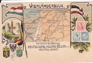
The Neutral Zone - or Vierländereck
(literally four-lands-corner) - was a popular motif for postcards from the turn
of the nineteenth century until the beginning of the First World War. At the most
northerly point of this Neutral Zone stood (and indeed still stand) four stone memorials. Each one represented a different country (Germany, Belgium, The Netherlands and the Neutral Area of Moresnet) and the point at which these four countries met.
Postcards simply depicting the stones were very popular (Fig.1). Another such card shows the stones and "Grenzwach" (border guards) officers responsible for the border, from each of the neighbouring countries. In addition a basic sketch map of the location of the Vierländereck, or four countries corner, can be found left (Fig.2).

The map used in a large number of cards is a simplistic plan of the immediate area (south and west of Aachen in Germany). Vaals, Aachen, Giinmenich (Gemmenich today)
and (New or Prussian) Moresnet are shown with typical, times taken to travel to
Vierländereck from the surrounding towns. The arms of the Netherlands, Belgium
and Germany with a Hearty Greeting (in Dutch) from the Neutral Area complete the
card.
3. Vierländereck - detail of map
This card was written and
posted from Wernigerode (in Germany) on 29th September 1899 and as with most cards
printed before about 1907 there is no space for a message, although the sender
of this card has added a greeting on the face of the card. Similar cards, differing
only in the central photo, have also been seen. While the histories of the surrounding
areas are known to most, the story of Moresnet, the Neutral Zone, is not so
widely known.
The defeat of Napoleon
at Waterloo brought with it a redefining of (Western) Europe's borders. The Vienna
Congress convened (1813) and the Kingdom of the Netherlands was created as a buffer
state between Prussia and France. However, neither the Prussians nor the Dutch could
agree on the border a few kilometers south-west of Aachen (or Aix-la-Chapelle)
in Germany and due South of Vaals (Netherlands).
The problem was that a profitable zinc and potassium mine was located here and, with zinc being vital for the production of brass both countries wanted to have control of it. The actual area involved was only a few hundred hectares around the main populated area of Altenberg, later called La Calamine or Kelmis. So it came about that in central Europe, after 2 years of struggle between the Dutch and the Prussians, Neutral Moresnet was born, a neutral zone between the two countries, and governed by both states. The Prussians founded Moresnet in German territory and in the West the little town of Moresnet came under Dutch rule.

4. Vierländereck - smuggling
However, in 1830 the
Kingdom of the Netherlands split up into the Netherlands and Belgium and Neutral
Moresnet now came under joint control of Belgium and Prussia. Although the Germans
invaded Belgium in 1914 they left Moresnet neutral. The Treaty of Versailles (1919)
transferred the Moresnet region to Belgium (together with the German districts
of Malmedy and Eupen). Although in 1940 the Germans annexed these territories, in
1944 they were returned to Belgium.
The mine was the main reason for establishing the neutral zone and it is fitting to look fleetingly at the development of mining in the area. Flint finds and hill barrows of the bronzeage are evidence of early settlements in the area. Evidence of zinc mining during Roman times can be gleaned from Pliny the Elder who reported Cadmia finds in the province Germania. In the Middle Ages the area of Kelmynberg (Kelmis) was controlled by the city of Aachen. In 1439 Duke Philipp took control of the mining which was subsequently administered by the authorities of Limburg, either themselves or as leaseholders.

5. Grüss aus ......
Ore exraction was a considerable source of income for the state and when King Philipp IV of Spain was forced to sell off many of his Limburg towns in the 17th century, he expressly retained conpol of this area: in het gehucht van Kelmis ende tgene daeraen cleeft ter oirsacke vande importante van onsen Calmynberghe aldaer. The regal township, Kelmis, whose central point was the Rochus chapel, extended over most of the area of present-day Kelmis and Nue Moresnet and remained so until reorganised by the French who brought together Kelmis and Moresnet as municipaliié de Moresnet. The French controlled the mining operations as government agency (1794-1814), but in 1805 handed the Kelmis concession over to the chemist J.J. Dony of Lüttich consisting at that time of mining area of some 8,500 ha, that stretched as far as Hauset (Fossey), Rabonath, Lontzen and Welkenraedt.
In the 19th century Kelmis experienced something of an industrial boom, especially after the founding of the company "Vieille Montague" in 1837 which determined the economic, cultural and social life of the town. By 1884 the Kelmis mine had been exhausted and the mining of the north section had left behind an enormous pit called the Kull which, after the final closure of zinc mining operations in 1950 was slowly but steadily filled with rubbish and building debris. This area has been systematically planted and made green, providing a large park area to the left of Schutzenstrasse, which is also used for markets and fairs. The observant visitor can sttll notice every step of the way traces of the mining operations; offices and buildings of Vieille Montagne, hills from digging, the zinc-roofed buildings and the postcards of Vierländereck.

6. Arms of the various regions
Most of the later cards of this area have another, more detailed, map on them. The typical postcard has the three monarchs, Kaiser Wilhelm with Queen Wilhelmine (1880-1962) and King Leopold II (reigned 1865-1909) surrounded by an art-nouveau leaf arrangement, above a map covering the atea from Vaais and Aachen to Hergenrath with the neural area central. The card illustrated here is slightly unusual in that the card is vertical, a photo of the memorials is included and it is, in fact, an advertisement for a hotel - hotel- Restaurant Franz Geller in Vaals (entrance next to the Dutch post office ). This was posted from Vaals in 1906 and again has no space set aside for a message. Intcrestingly in this card Kaiser Wilhelm has his harpoon helmet which is the typical picture we have of him: in most other cards he wears no helmet (and looks years younger!).
Some cards of this type
have the greeting Amikejo. This was an alternative name for Neutral Moresnet or
in Esperanto "Neutra- Moresneto". Dr Molly (of Neutral Moresnet) and the
well-known French Esperantoist Dr. Gustav Roy had plans to make an Esperanto
state of Neutral Moresnet. After rejecting The Hague in the Netherlands as
World Center for Esperantoists, it was decided at the fourth Esperanto Congress
in Dresden (March 1908) to found the Center in Neutral Moresnet.
The map and picture of the stones are represented on a further card of the area, this time in colour and with stamps depicted from each of the neighbouring countries. The three stamps depict (left to right): King Albert I of Belgium (reigned from 1909-1934) on a 10 centimes stamp first issued 1912/1913; Germania on a 5 Pfennig stamp; and Queen Wilhelmina (who reigned from 1890) on a 25 cent stamp.


7 & 8. Two postcards with monarchs and Moresnet
Many Moresnet cards are of some interest to philatelists as there is often a stamp
depicted that never existed. One such card, produced by the publishing company L Mond in Vaals
(post- 1907 but pre-1912) depicts a group of villagers and a customs
officer. He appears to have apprehended a smuggler at the Vierländerpunkt. As
well as stamps from Germany, Holland and Belgium there is a 10 Pfennig stamp vun
Moresnet poste inierieure (4).

9. Postcard with monarchs with stamps and coins
Postcards of the area from
the period between the wars were produced, however, these were mainly of buildings,
including the mine. Today, there is a museum, the Goehltal Museum, with exhibits
explaining the history of this interesting little comer that managed to stay “free“
for fifty years. As such, Neutral Moresnet only existed between 1817 and 1919.
In that time the district had its own flag (blue, white and black horizontal
stripes), stamps and very nearly had its own language.
This article was first
printed in CARTOMANIA (Newsletter of the
Association of Map Memorabilia Collectors) Issue 53/54 Spring/Summer 1999. It was subsequently reprinted in the journal of the Brusssels Map Collectors Society (of which I was a member). It is reprinted with the kind permission of Mr Siegfried Feller. This adaptation December 2021.
¹ I would like to acknowledge the help of Henk de Klerk for much of the background information on the history of Moresnet and Cees Damon who (in 1999) had a webpage on Moresnet at http://wwwserv.eaiw.nl/- cdamen/home.htm.
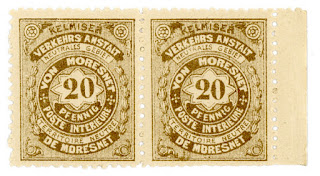
10. Vierländereck - 20 Pfennig stamp
All illustrations are from my former collection except for the final two above (9 and 10). These are from:
Philately can be found at https://www.klassische-philatelie.ch/pp/pp_moresnet.html with an article on the stamp history in German by C. Ozdoba - all rights reserved. There is a very entertaining story of an April Fool´s Joke played on a publisher who copied a story about the issue of these stamps
Other current (2021) sites offering illustrations and/or articles on Moresnet can be found:
King Kalli can be found at https://kingkalli.de/der-ort-der-freundschaft-das-neutrale-gebiet-von-moresnet/ together with an article in German from 2015.
History https://historiek.net/misverstandje-moresnet-overleeft-bizarre-eeuw/58091/ where an article in Dutch can be foundSchutz Gebiete can be found at https://deutsche-schutzgebiete.de/wordpress/vierlaendereck/ with an article in German
Mindat can be found at https://www.mindat.org/photo-1030122.html with notes in English on Kelmis - Altenberg was the largest of the mines
Delcampe can be found at - https://www.delcampe.net/nl/verzamelingen/postkaarten/belgie/kelmis/ This is a postcard seller (some cards on sale for circa €10 in December 2021)
Wikipedia can be found at https://en.wikipedia.org/wiki/Neutral_Moresnet with artcles in English, German and Dutch
A further article in English can also be found at Low Countries https://www.the-low-countries.com/article/100-years-ago-tiny-country-neutral-moresnet-became-part-of-belgium together with an article in English from 2020
A further article in French and stamps can also be found at --https://www.trois-frontieres.be/D/moresnet_neutre.php


And finally from the Digitale Bibliotheek voor de Nederlanske at

Comments
Post a Comment